Parrett and Yeo Phosphate Pollution Study
A citizen science investigation


Cartgate2020
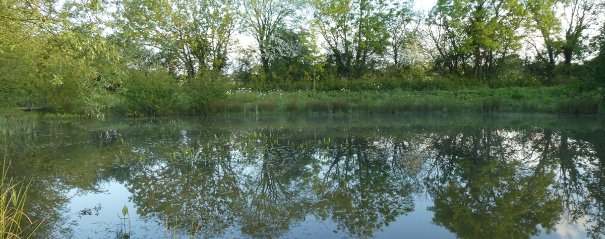
Cartgate pond, Martock, May 2020. Consistently free of excessive phosphate despite being fed by a phosphate-rich stream.

Home

Measuring phosphate pollution in the Somerset Levels catchment

This is a report of an ongoing Citizen Science Project looking at phosphate levels in tributaries of the River Parrett in and around Martock Parish. It started early 2021.

The study was established when all new house building was put on hold in the Parrett catchment following a High Court (European) ruling that a number of Internationally important (Ramsar) wetland sites were not being managed in a manner that was lawful and were in a declining ecological state. The Catchment Area of the Somerset Moors and Levels was one of these areas and the offending pollutant was excessive phosphate nutrient.

At the end of 2020 Natural England initiated a ban of all development in the Somerset Levels catchment area that was not accompanied by a statement (see 'background documents' to the right) showing that it would not generate a net increase in phosphate in the catchment. This was a climax in a decades long story of declining biodiversity in the area that we were all aware of. Rather astonishingly, though, nobody had undertaken any systematic survey in the area to obtain precise field data. It was to fill this gap that the Project was started and this website maps the results and highlights the patterns uncovered.

The website focuses on the phosphate in the upper catchment of the river Parrett, most partcularly in Martock and neigbouring parishes. It extends from South Perrott ustream as far as two Moors, Wetmoor and West Sedgemoor downstream and includes the lower reaches of the Yeo.


Emerging messages from this study

1 The main sources, by far, of phosphate in the Parrett are the eleven sewage treatment plants whose outflow enters the river. None has a phosphate removal stage. The most significant are Crewkerne, South Petherton, Martock and Langport. The study shows that that these account for over 90% pf the phosphate enetering the river; this contrasts with the the picture given by the water agencies which relies on modelling rather than direct evidence. More...(link page under construction)

2 Where farmers follow DEFRA guidance for farming near water phosphate run-off into watercourses is almost always undetectable.

3 Some large dairy farms generate point source run-off of phosphate that is seasonally variable and often considerable. The most significant are at Haselbury Plucknett, Ash and along the north-west side of West Sedgemoor

4 National surveys and modelling suggest that 'diffuse run-off from agriculture' is a significant contributor to phosphate pollution. This study finds very little evidence of this in the Parrett catchment. More...(link page under construction).

5 The streams fed by groundwater springs at the base of the Yeovil Scarplands to the east of the Parrett show normal levels of phosphate - varying from zero to around 0.1ppm according to season.

6 Slowing the flow of phosphate polluted watercourses is an effective way of removing the phosphate; all ponds, including flood retention ponds, and some Moor drains tested when slow flowing, usually show little detectable phosphate.

7 The River Parrett has a much higher concentratioin of phosphate than its tributaries. This suggests a significant role for the river sediment in the phosphate flow. More..(link page under construction)

8 Most of the Parrett flow does not enter the Moors and Levels but is directed across the top, between high levees, to the estuary in Bridgewater Bay. A small amount, probably less than 5%, flows through inlets onto the Moors during summer. These inlets are manually controlled. More..(link page under construction).

9 The mass of phosphate passing the EA monitoring station at Chiselborough varies from around 40kg/day when the river flow is low to several hundred kg/day when it is in spate. More..(link page under construction)


Links

Study Reports
Reports are being produced from time to time as the study develops that focus on particular issues. They are directed at lay readers, particularly those such as Local Councillors who need the information in their work.

Follow these links.
1 Upper Parrett
2 Witcombe Bottom
3 Wetmoor
4 The Parrett during the 2022 drought

Background documents

Local Authority pblications
Somerset County phosphate briefing letter
, 2021
South Somerset phosphate briefing letter, 2021

Natural England reports, letters and press releases
-Press release downgrading the environmental status of the Levels due to phosphate levels
- Letter to Somerset and Dorset Councils on developments affecting the levels catchment area
- Somerset levels Profile. Somerset Moors and Levels National Cgaracter Area Profile.
- Somerset Levels Conservation Objectives (2019)

Environment Agency reports, letters and press releases
Phosphorus and Freshwater Eutrophication Pressure Narrative (2019)

DEFRA guidlines on farming near watercourses.
Rules for farmers and land managers to prevent water pollution

Parish phosphate data from the Environment Agency
The Environment Agency collects monthly data in the Parish. Those for the last decade are here (xls files).
Parrett data.
Hinton Meads Brook and Mill Brook .

Environment Agency data - all rivers
The Environment Agency publishes data for many solutes on all rivers here on the DEFRA site
Extracts from the 2021 phosphate sampling of nearby stretches of the Yeo and Parrett are here

[Note that the Environment Agency sampling is expressed as 'total phosphate as P', the convention now used; I have converted this in the data to the older convention of orthophosphate used elsewhere in this document, to facilitate comparisons. The conversion multiplier is 3.06. See experimental pages for more details]

The Ramsar Convention
The Ramsar Convention on Wetlands is an intergovernmental treaty that provides the framework for national action and international cooperation for the conservation and wise use of wetlands and their resources.www.ramsar.org

About Hills to Levels
This is a Somerset catchment management approach to slowing river flow at times of greatest flood risk. It is funded by the Somerset Rive authority and managed by Farming and Management Group, South West (FWAGSW)


Navigating these pages
The right columns contain links to more information, sources and data relevant to the discussion in the main columns
The Menu bar gives access to different parts of the study
Sources - A summary account, with photigraphs, of where the excess phosphate is coming from
Experimental - Technical details of the experimental procedures
2021 and 2022/23 Data - Results, discussion and emerging detailed conclusions.

Existing phosphate monitoring in the upper Parrett catchment area
Phosphate in the watercourses of the Levals catchment is measured routinely by the Environment Agency and Wessex Water monitors the impact of their sewage plants. Both organisations have been helpful in sharing their data (follow links on the right). Both organisations, however, only sample the main watercourses which provides useful information about the extent of the problem but very little about its causes.

The 2021 Study Areas
1 The River Parrett and minor tributaries In Martock Parish
2 The Wellhams Brook Catchment Area between Martock and Yeovil
3 The Witcombe Area of Ash Parish and the River Yeo

The 2022/23 Study Areas
1 The upper Parrett above the A303 bridge at Martock
2 The Hills-to-Levels flood protection scheme in Wellhams Brook, Martock
3 Witcombe Bottom and Wetmoor

4 West Sedgemoor
5 Chiselborogh Bridge EA monitoring station (2023)


Last modified 19/4/23