River Parrett map


.

Home > Results > Parrett > Maps

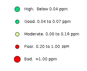
River Parrett map

The east part of this map shows the Parrett and some small tributaries within Martock Parish . Zoom in as appropriate. The sample points are coded according to the legend. Parrett points are prefixed with a P.

Click on any point to display the data on the left. If more than one point is clicked both will show; click on the one you want.


The interactive map below may not load in certain browsers (particularly Safari). To launch it in a separate window follow this link


The river Parrett shows a consistently high level of phosphate pollution with the concentration varying roughly inversely with the volume of water flowing. In winter the normal flow drains the system of rhynes throughout the Parish taking any leached nutrient out to the Bristol Channel. During any flooding the drainage system works to protect downstream towns particularly Bridgewater which often results in widespread flooding rising and falling with the tides. Flooding allows nutrient rich water onto the land.

Sewage outlows
The river is fed by several Sewage outflows including Martock, South Petherton and Huish Episcopi in this section, none of which have a phosphate removal stage. Their combined input can account for up to about 25% of the phosphate in this section of the river. The South Petherton STW feeds into Lambrook Brook and may be the main reason for its high phosphate level. This will be studied further.

Main tributaries
The main tributaries in this area are the Wellhams Brook system–which joins the Parrett just upstream of Gawbridg–and Lambrook Brook which flows in from the west. All tributaries except one (below) showed levels of phosphate which showed a seasonal variation from moderate to poor. This issue is complicated by the drainage arrangements in the north of the parish which, in general, allow water to flow from the land into the Parrett in winter and in the opposite direction in summer.

Small Moor Brook in the south of the Parish
In the south of the Parish, a sytem called Small Moor Brook drains Ringwell Hill and the high land between Percombe and Stoke sub Hamdon (passing under the A303 in a culvert). The land to the east of the A303 is mainly soft fruit farming and to the west a dairy-driven crop rotation. Both areas have 6m field margins, particularly where the land is sloping. Deep land drains drain the low level fields in this catchment. Small Moor Brook was tested one field short of its confluence with the Parrett (P5 ) and the phosphate level was undetectable.

Ponds draining adjacent fields in the south of the Parish
Three ponds in the south of the Parish were also tested (P3, P4, P6). These ponds drain the adjacent fields, fill during the winter and are used for irrigation during the summer. In all three, the phosphate level was undetectable when tested in spring when depths were maximum after the ponds filled.


Map Legend

Map legend

Data
Download the full Parrett data (Excel file)

Maps produced using Parish Online. Contain OS data © Crown copyright and database right 2021,© Crown copyright and database right. All rights reserved (100054346) 2021