The dominant soil type in the area of the study is deep heavy clay. It is very fertile being classified in the main as grade 3A soil with some areas of grade 2 in the valley bottoms. Clay soil is absorbent, being able to absorb sometimes up to 60% of its own weight of water but the rate at which it absorbs water is very slow. These properties have a number of consequences:
- Heavy storms can cause sudden flash floods when the rate of absorbance into the soil is too slow to cope with the rainfall. Fine grains of the surface clay are often washed off (together with any soluble nutrient) giving the water a typical milky appearance.
- During periods of heavy rain, water that enters the soil tends, mainly, to run laterally through the top layers of clay into any nearby ditch, taking with it some of the soluble nutrients.
- Rainwater is best able to penetrate the clay soils when the soil is well vegetated, particularly if some of the plants have long roots. Thus run-off from permanent grassland is typically much less than run-off from cultivated land, particularly between harvest and subsequent sowing.
- As water is absorbed through clay, dissolved nutrients such as nitrate and phosphate are gradually removed and held in the soil.
- Clay soils tend to retain nutrients more effectively than sandy soils releasing them more slowly into ditches over a longer period of time.
- Phosphate forms very insoluble compounds (in contrast to nitrates which are all soluble) and is strongly absorbed by clay (in the form mainly of iron and aluminium phosphates) and so is removed from water percolating through it.
- Run-off is greatest from compacted soils. For this reason DEFRA advises farmers to break up the surface of clay soils immediately after compacting activities such as harvesting. This is particularly noticeable in this region after maize harvests.
The seasonal variation in phosphate is further complicated by the complexity of the operation of the drainage processes in the Levels catchment. These processes have two basic aims; to stop the flooding of population centres on the one hand and to stabilise the level of the water table on the other. This means that, in winter, the water, and hence the phosphate, in the main rivers normally tends to flow largely uninterrupted into the Bristol Channel. (This routine may be temporarily changed in the event of a flood during which excess water may be actively diverted onto the Levels away from town centres.) In summer, however, the drainage system is designed to retain water on the Levels with the result that nutrients such as phosphate are concentrated there,
DEFRA has long recognised the importance of field margins both for reducing run-off and also for reducing the leaching of soluble nutrients such as phosphate by water running through the soil. The gist of its guidance (link on he right) is that fields adjacent to watercourses should have a margin of 6 m, particularly if the field slopes towards the watercourse, and also particularly if slurry is used as a fertiliser. Observance of this principle is variable but what is very clear from our results is that where they do follow the advice, the concentrations of phosphate reaching the rivers is very low.
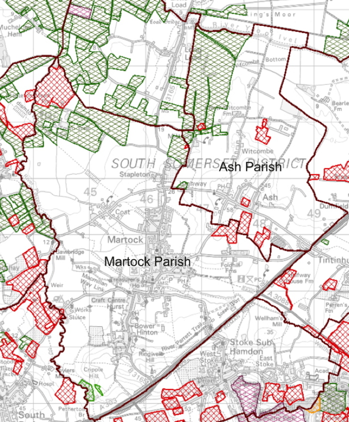
Of particular significance locally has been the recent establishment in the study area of a large intensive dairy units. Most of the land in Ash and Martock, for example, is now dedicated to producing feedstock for a 3000 head unit in Ash. This is mainly in the form of cultivated rye grass and maize. The map below shows that the uptake of different schemes to replace the Basic Support Grant that farmers received under the Common Agricultural Policy. The strikingly low uptake of any of these schemes in the two parishes suggests that farmers here, instead, have chosen contracts to supply the dairy. |
Farming Rules for Water, Policy Paper 2018. Guidance for farmers on how to minimise the impact of fertiliser on watercourses
Phosphorus and Freshwater Eutrophication Pressure Narrative.
This is an overview by the Environment Agency of the steps proposed to reduce phosphate levels in watercourses. At the time (2017) the EA took the view that agriculture contributed around 25% of phosphate in watercourses.
This study suggests that, in the Level catchment, agriculture contributes nearer 75% and the overall phosphaye concentration is rising.
|
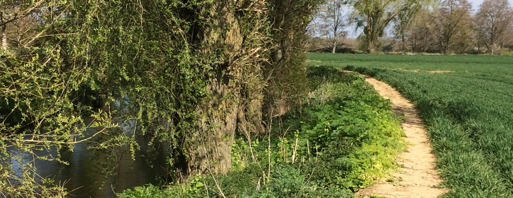 Wheat field next to the River Parrett (phosphate 1.77ppm when this picture was taken). The phasing out of the direct payments scheme and the recent reduction in the width of field margins are probably not coincidental.