Martock watercourses
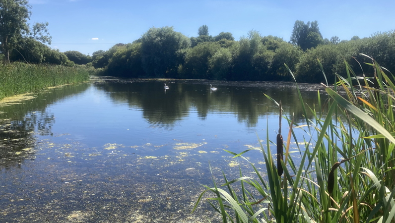


ICartgate.Cartgate pond, Martock Parish. One of the Hill-to-Levels flood defence ponds. Phosphate 0.00ppm fed by a stream about 0.3 ppm

Home - 2022 Data - Martock

Martock Parish Watercourses
The River Parrett forms the western boundary of Martock Parish. The flow involves two former weirs and associated mill races. The parish marks the upper limit of levees to control the flow at times of flood. Three tributary systems join the river, one (Lambrook Brook) from the west and two from the east, including a substantial stream, Wellhams Brook (otherwise known variously as Hinton Meads Brook and Hurst Brook) which rises on the edge of Yeovil.

Two sewage works discharge into the river in this section; South Petherton (via Lambrook Brook) and Martock which discharges directly into the Parrett just downstream from Gawbridge. Neither have phosphate removal stages (a feature in common with all sewage treatment plants in the Parrett catchment from its source to Langport.

The Wellhams Brook confluence is the source of periodic flooding in the village caused by water flow backing up the Parrett reducing the outlow at the confluence. This flooding has given rise to the Martock Hills-to-Levels flood relief pond system in Wellhams Brook which incorporates a sequence of ponds that can be used to hold back the flow at times of high rainfall.

Wellhams Brook brings water from the Yeovil scarplands to the east via springs and clay run-off. Upstream from Martock it divides into the old Madey Mill Race (Mill Brook) which is now the main stream through the village. The level in Mill Brook is controlled by a tilting Weir with summer and winter settings. The summer setting diverts almost all the water into Mill Brook leaving the second stream, Hinton Meads Brook subject to a very variable flow.


Data Map
A map showing sample details for the Martock Area (incuding the Hill-to-Levels upstream sampling) is shown here. Zoom in and click on a sample to show data. (Does not open correctly in Safari)

Map legendMap Legend
Data download
The data for the objects on the map can be downloaded here and opened in Excel or similar (updated 16/9/22)

Martock Sewage Works storm overflows
Martock Sewage works has a storm overlow into Hinton Meads Brook. It was triggered 56 times in 2021 for a total of 522 hours (total volume unrecorded). Hinton Meads Brook during the summer has a typical very low flow rate and overflows are not significantly diluted. Neither do they appear to be filtered leading to toilet paper being caught on overhanging vegetation. Storm overflows lead to spikes in phophate downstream, some of which have been picked up in the survey


The Hill-to-Levels Flood alleviation scheme
The 2022 survey of the Parrett and its tributaries in Martock Parish, includes a study of the potential for the Hills-to-Levels scheme to remove phosphate from Wellhams Brook. Several artificial ponds are being sampled. Lufton pond is a significant nineteenth century garden water feature now on the outskirts if Yeovil. A series of ponds at Odcombe and Montacute drain the north slopes of Ham Hill. Cartgate pond (pictured above) was created to supply water when the adjacent A303 trunk road was dualled in the 1980s.

The Hills-to-Levels flood alleviation scheme involves the constuction of a number of structures to slow the flow of Wellhams Brook in heavy rain. The most significant are a number of retention ponds and dams which can be emptied in anticipation of rain in order to retain water at the time of a potential flood.

These retention ponds have been investigated to evaluate their potential for absorbing phosphate during the growing season and releasing it again when the plant life decays. The growing season corresponds to times when the retention ponds are full and they are most likely to nbe emptied in autumn/winter when growth has decayed releasing phosphate into the water.

Testing shows the ponds to be normally largely free of phospate and have considerable capacity to absorb it from polluted inlets. What we do not see yet, however, is a significant rise in phosphate in solution in the autumn. This may be because it is absorbed and held in the sediment.

While the Hills-to-Levels ponds have undoubted potential to absorb phosphate, this does not widely occur in practice as only one of the ponds (Cartgate) is fed by a stream that has a significant phosphate concentration; the others come from relatively pristine springs at the base of Ham Hill.

OdcombeOne of the Hills-to-Levels artificial ponds created upstream from Martock near Odcombe. Phosphate undetectable at the outflow, low at the inflow.


Comments

1 The main sources of phosphate, are the two sewage works
at Martock (sample pont D) and South Petherton (sample point K). The outflow from martock Sewage Works just downstream from Gawbridge raises the phosphate concentration in the river by around 25%.

2 Wellhams Brook is contaminated somewhere along its course by small sources, possibly by agricultural run off. This concentration doubled during the drought (the flow rate halved) but is still considerably below the Parrett - and so produces a small reduction in the Parrett concentration. This concentration appears to be seasonally variable.

3 Hinton Meads Brook receives the storm overflows from Martosk Sewage works. Because the flow rate in the Brook is under automatic control it frequently runs very low in summer which means that the Sewage Works discharges into an almost dry ditch and much solid discharge is left in the Brook.

4 Small ditches and streams are larely free of phosphate. This is particularly noticable in areas where the Defra Rules for Farming near Water are observed.

5 Ponds remove phosphate from water. All ponds in the area are phosphate free, even when feeder streams are contaminated.


Last updated
18/10/22